Day 24: Red’s Meadow to Rosalie Lake

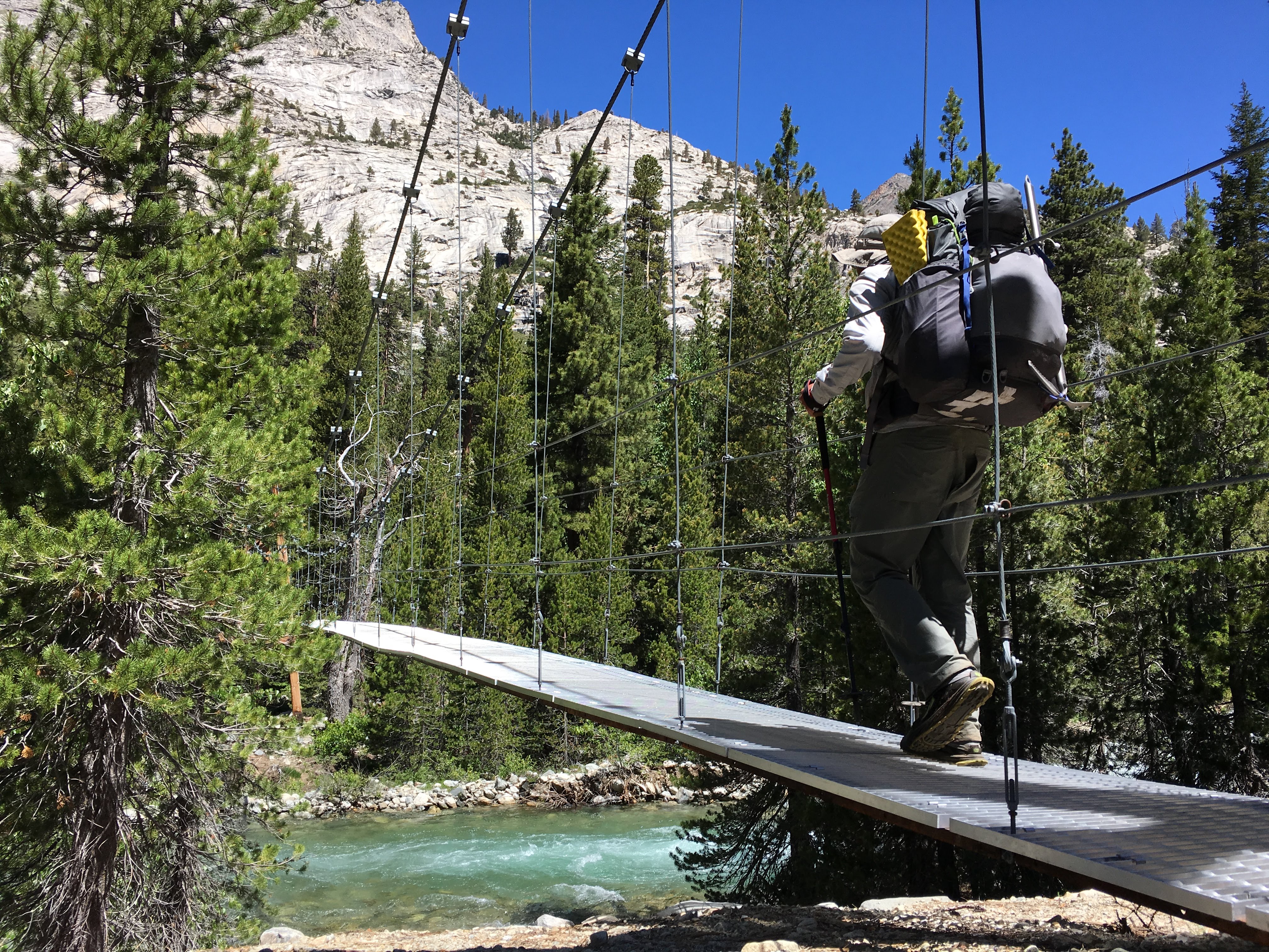
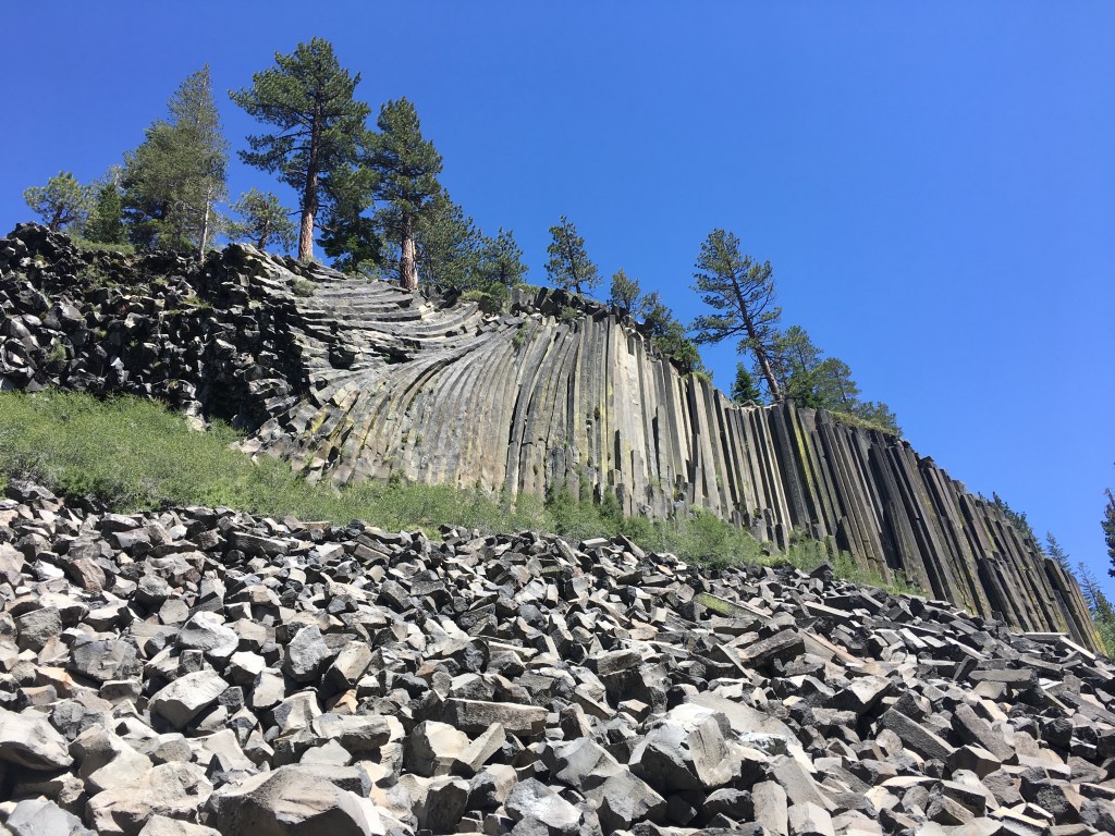
After a leisurely breakfast at the eponymously named Breakfast Club, I loaded up on tortillas and ramen at Grocery Outlet and we caught the bus back to Red’s Meadow. A slight detour led us through Devil’s Postpile National Monument, a large jumble of hexagonal basalt columns jutting out of the landscape akin to the Giant’s Causeway in Northern Ireland. Feeling slightly out of place with our big backpacks amidst the crowd of car tourists, we didn’t linger long and quickly crossed another swollen creek back into the wilderness.

Since Mount Whitney, the PCT had traced the same route through the High Sierra as the shorter (but no less famous) John Muir Trail. Just north of the Postpile, however, the two trails split for about 14 miles with the PCT following a higher ridgeline and the JMT plunging along a lower route next to a series of lakes. As Meredith had a JMT permit and the lake route appeared to offer more interesting scenery, we chose to take it and were rewarded with a beautiful campsite atop a rocky bluff overlooking Rosalie Lake. It was the perfect place to watch the sunlight fade over the granite dome across the way, fish leaping into the air for an insect dinner below.

Day 23: Duck Lake Outlet to Red’s Meadow

The way to the small resort at Red’s Meadow led past a friendly trail crew clearing downed trees and into a large burn zone, the result of a fire sparked by lightning back in 1992. Between the burnt out husks of pine and fir a colorful milieu of purple lupine and white and yellow flowers bloomed, attracting a somewhat alarming number of bees. Hustling under the hot sun, we arrived at Red’s Meadow just in time to enjoy a delicious pastrami and swiss sandwich, the start of a hedonistic bender that would define my time in Mammoth.

Ten days in the mountains can really work up a hiker’s appetite, and as soon we got set up with a room at the Motel 6 in town I proceeded to gorge myself on a truly disgusting amount of food and drink. Coffee, pizza, donuts, beer, whiskey; everything was fair game in my rush to enjoy the fruits of civilization. Unfortunately for my stomach, the extreme mix of foods, caffeine, and alcohol had a rather unsettling effect and I spent most of the later evening in the hotel bathroom. But for those few hours hopping through town from cafe to pub, I was in heaven.

Day 22: Mott Lake Junction to Duck Lake Outlet

In the morning we were immediately treated to the Silver Pass Creek waterfall, a brilliant cascade falling across a series of granite steps right above the trail. The aptly named silvery water flowed directly over the path for about 20 feet, soaking my feet but inspiring sheer joy as the cold spray reflected the bright morning light in a million different directions.

From the creek we made the climb up to Silver Pass itself, where a giant snowfield obscured the path ahead. Lucky for us, previous hikers had blazed a long chain of glissades across the snow and straight down the mountain. Nothing for it, we hitched up our trekking poles and gleefully slid all the way to the small lake at the bottom of the pass, bypassing a solid mile of postholes and half-melted snow.

Arriving at our planned campsite we found most spots already taken, but I managed to set the tent up on top of a granite slab using large rocks for anchors in place of the usual stakes. We spent the evening around a fire with a group of young John Muir Trail hikers and a couple of southbound Danes, who had braved Forester Pass during an intense snowstorm back in May. The group’s energy was infectious, and after more than a week in the wild I was very glad for the company.

Day 21: Marie Lake to Mott Lake Junction

An early start from the serene Marie Lake led us down to the ford at Bear Creek, regarded as one of the most dangerous crossings on the PCT. Around 9am the current was flowing strong, but after surveying the scene and noting that the closest log crossing was a quarter mile downstream, we decided to try crossing at the trail. At midstream the chilly water rose almost to my waist, threatening to push me over and into a long, unfortunate ride down the river. Taking it one slow step at a time I managed to withstand the flow and reach the opposite shore, soggy but safe.

Once we strapped our packs back on and dumped the water out of our shoes, however, we were immediately set upon by a horde of mosquitoes. Walking fast kept some of the supremely annoying insects from landing on me, but I couldn’t outrun them all. Luckily I had brought a head net and quickly slid it over the brim of my hat. As we passed along Bear Creek down toward the turnoff to Vermilion Valley Resort (a popular hiker stopover), I noticed a single solid hiking boot left abandoned on the side of the path, and could only assume that its owner had succumbed to the cloud of mosquitoes relentlessly chasing me into the hot afternoon.

Day 20: San Joaquin River to Marie Lake

IMG_3490(1)

Leaving Kings Canyon in the cold shadows of the early morning, we took a short detour from the PCT to Muir Trail Ranch. In the long stretch of trail between Independence and Mammoth, shipping a food bucket to MTR is one of the only options if you want to resupply. I collected my bucket (they don’t allow boxes because of the rough overland journey it takes to get there) from a shed near the entrance and we began the process of dumping trash and sorting food. While divvying up oatmeal and ramen packets we met a friendly family hiking the John Muir Trail, who offered us their extra oreos and non-perishable bacon (I had no idea this existed). We greedily scarfed down everything they were willing to give us, and with contentedly full stomachs left the Ranch to continue our journey.

The path back to the PCT proved difficult, as we earlier had descended to MTR and now faced a very steep, hot, and exposed trek up toward Selden Pass. Soon enough, however, we were back among the snowfields, waterfalls, and placid alpine lakes of the high mountains. After dealing with some slick ice on the north side of the pass I went on the hunt for a dry campsite next to Marie Lake. When I walked over to a promising spot near the water, I heard a piercing yell and glanced to my left just in time to see a pair of naked hikers leaping into the half-frozen lake. The hikers later joined us for dinner and one, a photographer from Bulgaria, showed me how to take photos of the perfectly clear night sky with his SLR camera, capturing the light of a million stars.

Day 19: Sapphire Lake to San Joaquin River

IMG_3451

By the morning Meredith’s leg was feeling better and we set out into the valley, passing by the very serene Evolution Lake and watching fat marmots pop in and out of nearby jumbles of gray rocks. I had been warned that Evolution Creek posed a potentially dangerous crossing at the trail (hikers have been known to get swept away by the current, especially in high snow years) so we took an alternate route through a mud-filled meadow to cross at what turned out to be a relatively deep, but wide and shallow, section of the creek. The other side proved to be equally muddy.

A long, steep descent past gnarly old juniper trees followed, until we arrived at the valley floor and a pair of bridges across the South Fork of the San Joaquin River, which eventually flows all the way into San Francisco Bay. We camped next to the river, and as this would be our final night in Kings Canyon National Park I decided to build my one and only campfire on the trail to celebrate.

Day 18: Grouse Meadow to Sapphire Lake

IMG_3364

The approach to Muir Pass was long, but mostly it was snowy. For almost three full miles leading up to the crest, we tramped past frozen lakes and infrequent rock outcroppings through deepening snow. Bubblewrap, Pioneer, and an Australian friend played catch up with us as we took turns hiking past each other. At last, after a final push up a steep snow hill, we reached the stone beehive-esque shelter at the top. Having been assaulted by blinding light reflecting off the snow for much of the morning, the inside of the hut appeared pitch dark. Soon my eyes adjusted, and together with a large group of international hikers I put my feet up and enjoyed a well-deserved bag of peanut M&Ms.

The trail north of the pass looked straight from the planet Hoth. Glinting ice and snow surrounded us as we slogged our way along the melting boot track, trying to make it to a flat, dry spot to camp before sundown. Beautiful icicle blue water peeked out from the completely frozen Wanda Lake. We crossed sketchy snow bridges, hoping that they wouldn’t collapse and send us into the freezing water running underneath. The sun was approaching the mountain peaks to the west when Meredith started complaining of a sharp pain in her leg. We slowed our pace and took several rest breaks, aiming to get to the next campsite at Evolution Lake. But the pain grew worse, so I decided to set up an emergency camp on a tiny ledge overlooking Sapphire Lake. The view was breathtaking, and while Meredith rested in the tent I watched the last rays of the sun disappear while the moon rose behind Mount Huxley, feeling the cold seep in.

Day 17: Mather Pass to Grouse Meadow

IMG_3324

Mather Pass has one defining characteristic: a 15-foot wall of snow at the apex that hikers must climb straight up and over, with a very long and steep drop waiting if you fall. My heart rose to my throat as stepped into boot tracks that became smaller and smaller as I ascended, until there were no tracks left. Tossing my ice axe and trekking pole onto the ledge above, I breathlessly scrambled onto the relatively flat crest to the sound of clapping from a group taking a snack break at the top. They had come up the north side of the pass, and while I watched them one by one begin to descend the precarious snow wall I was grateful to have gone up the south side instead of down.

Hiking down into the Palisade Valley was like entering a frozen wonderland at the very edge of spring. Waterfalls sprang from every direction, flowing into two large lakes half covered in ice and half in deep blue glass. We ran into my old pal Bubblewrap’s group as they lazed on a rock in the sun and spotted several furry marmots on our way out of the paradisaical valley, following a trail that often disappeared under several inches of water. Navigating over and under fallen trees, we continued north and set up camp at the edge of a grassy meadow beneath granite spires.

Day 16: Pinchot Pass to Mather Pass

IMG_3263

Hiking over Pinchot Pass was easier than the previous two passes, but it still involved a long uphill slog through large snowfields and scrambling across a couple of treacherous outcrops of razor sharp rocks. By this time I had grown somewhat used to the High Sierra landscape of barren, brown peaks dusted with snow and interspersed with forested river valleys. It contrasted greatly with the mostly tree-covered mountains and gray granite in the Tahoe area where I grew up, only a few hundred miles to the north but significantly lower in elevation.

From Pinchot the track wandered down to the South Fork Kings River where a ranger had posted a sign warning not to cross the raging waterway at the trail. Instead we followed the ranger’s suggestion to trek upriver for 1.5 miles to a green meadow where the river braided into five or six smaller streams. Incidentally this was also the only point along the entire PCT when a ranger checked my permit. After a couple of false starts we managed to find the crossing and rejoin the PCT on the other side, winding its way back up toward the river’s headwaters and Mather Pass.

Day 15: Arrowhead Lake to Pinchot Pass

IMG_3219

At the bottom of Arrowhead Lake a deep and wide outlet flowed down the valley into the south fork of Woods Creek. Luckily it was moving at a slow, lazy pace and though cold, crossing the thigh-deep stream did not pose much of a challenge. The tributary led us down to its confluence with the main current, where this remote (and rather convenient) suspension bridge spanned the creek.

A long, hot climb followed as we made our way along the rushing creek and across tumbling side streams to Pinchot Pass, named for the first director of the US Forest Service. Setting up camp on a hilltop just before the pass, I attempted to collect some water by filling my bottle with snow and placing it on a rock in the sun to melt, which turned out to be very inefficient in the rapidly cooling evening air. I sat out under a half moon watching the sun disappear behind the ridgeline, painting the mountains in pink alpenglow.